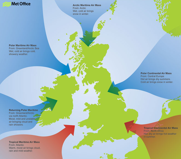
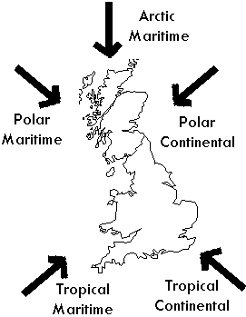
The origins of this air mass is North Africa and the Sahara Desert (a warmsource region). It’s most common in the summer months of June, July, and August, but it can happen any time of year.
The UK’s maximum temperatures (over 30 °C during the day and about 15 to 20 °C at night) are normally caused by tropical continental weather.
Due to contaminants picked up by the air during its passage over Europe and sand particles blown into the air by Saharandust storms, visibility is typically moderate to poor. Occasionally, the Saharan dust is washed out in storms, resulting in coloured rain and a thin layer of orange dust on vehicles.
This air mass has its origins over the snow fields of Eastern Europe and Russia and is only considered a winter (November to April) phenomena.
During the summer with the land mass considerably warmer, this air mass would be classed as a tropical continental.
The weather characteristics of this air mass depend on the length of the sea track during its passage from Europe to the British Isles: this air is inherently very cold and dry and if it reaches southern Britain with a short sea track over the English Channel, the weather is characterised by clear skies and severe frosts. With a longer sea track over the North Sea, the air becomes unstable and moisture is added giving rise to showers of rain or snow, especially near the east coast of Britain.
The lowest temperatures across the British Isles usually occur in this air mass, lower than -10 °C at night, and sometimes remaining below freezing all day.
This air mass has its origins over northern Canada and Greenland and reaches the British Isles on a north-westerly air stream.
Polar maritime is the most common air mass to affect the British Isles. This air mass starts very cold and dry but during its long passage over the relatively warm waters of the North Atlantic its temperature rises rapidly and it becomes unstable to a great depth.
This air mass is characterised by frequent showers at any time of the year. In the winter months when instability (convection) is most vigorous over the sea, hail and thunder are common across much of the western and northern side of the British Isles. However, eastern Britain may see fewer showers as here the surface heating is reduced. During the summer, the reverse is true, land temperatures are higher than sea temperatures and the heaviest showers occur over eastern England.
An arctic maritime air mass has similar characteristics to a polar maritime air mass, but because of the shorter sea track the air is colder and less moist.
Arctic air is uncommon during the summer, but when it does occur it may bring heavy showers or thunderstorms and unseasonably low temperatures.
Between October and May, the air is cold enough to produce hail showers or snow, and these are most frequent over Scotland and along the coasts exposed to northerly winds.
An arctic maritime air mass has its origins over the North Pole and the Arctic Ocean.
Polar low-pressure systems forming in this air mass can sometimes lead to widespread and heavy snowfall, but otherwise inland areas remain free of cloud in the winter months. In northern Scotland, arctic maritime is usually the coldest air mass, but over the rest of Britain, this air mass is not as cold as polar continental.